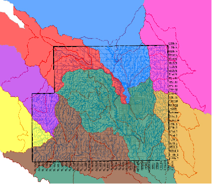
Watersheds
We all live in a watershed. A watershed is an area of land whose surface water drains into a river, lake, or stream. Ridges and hills form the boundaries of the watersheds in Sedgwick County. Mountains form the boundaries of large watersheds. Watersheds come in all shapes and sizes, ranging from a few acres to several million acres. Many smaller watersheds are inside a larger watershed.
Across the nation, watersheds have been negatively impacted. Previous generations failed to consider the effects of discharging industrial chemicals and raw sewage directly to our rivers and streams. That all changed with the passage of the Clean Water Act Water in 1972. The Clean Water Act created the National Pollution Discharge Elimination System (NPDES). NPDES is a program that regulates the sources of surface water pollution. Pollutants can enter water from a variety of pathways. Pollutants come from agricultural, domestic, and industrial sources. These sources are categorized as point sources or non-point sources. Point sources are easily identified. They discharge wastewater from the end of a pipe or a ditch. Municipal wastewater systems and industrial operations are
point sources that require a NPDES permit.
The Kansas Department of Health & Environment (KDHE) issues NDPES permits. These permits specify what treatment may be needed and the acceptable levels of pollutants that can be discharged into surface waters. Point sources test their wastewater and report the results to KDHE. Communities with populations greater than 100,000 are required to have a storm water permit. Wichita, and because of their proximity to Wichita, Derby, Maize, Mulvane, Park City, Sedgwick County, and Valley Center have storm water permits. These communities regularly test their storm water. They also gather samples during storm events.
Non-point source pollution is found in the water that runs off large areas of land. Commonly called storm water runoff, this water picks up pollutants and soil from agricultural land, construction sites, streets and highways, recreational areas, and residential lawns. Non-point source water is untreated and flows directly to our rivers, lakes, and streams.
Testing the Waters
Many organizations test surface water in our area. The City of Wichita, Sedgwick County, the Kansas Department of Health and Environment, The Kansas Department of Wildlife and Parks, and The United States Geological Society gather samples at various sites throughout Sedgwick County.
Water samples are tested for bacteria, nutrients, metals, and chemicals. Temperature, pH, dissolved oxygen, and turbidity are also recorded. Fish, insects and mussels are studied. Their presence, or absence, is an excellent indicator of water quality. When testing reveals that water quality has deteriorated, the site is then declared impaired by KDHE and plans to improve water quality are implemented.
Water tests show that several lakes in Sedgwick County are impaired. These include: Cheney Reservoir, Lake Afton, Cadillac Lake (Pracht Wetland), Watson Park Lake, and Horseshoe Lake and Kid’s Lake in Sedgwick County Park. Segments along the Arkansas River, the Little Arkansas River, and Cowskin Creek are also impaired. Programs to improve water quality are ongoing in many watersheds throughout Sedgwick County.
Special effort has been directed to landowners in the Cheney Lake Watershed and Lake Afton Watershed. Animal waste systems, waterways and terraces, grassland retention, cover crops, filter strips and conservation tillage are improving water quality. Surface water monitoring continues in both watersheds to evaluate these efforts and identify future needs.
The Cheney Lake Watershed is of special importance to the City of Wichita. The majority of Wichita’s water supply comes from Cheney Lake.
What can be done to protect our surface water?
- Use phosphorous free fertilizer for lawns. The middle nutrient number on a phosphorous free fertilizer bag will be zero.
- Apply fertilizers and pesticides at recommended rates. Avoid application when rain is likely in the next 24 hours.
- Never discard trash or yard waste down storm drains or in streets.
- Properly dispose of pet waste.
- Plant a rain garden to catch and hold storm water in your yard and at your business.
- Avoid washing your car on a driveway or in the street.
- Encourage local developers to use porous pavement.
- Take used oil and all unwanted chemicals to the Household Hazardous Waste Facility.